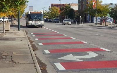
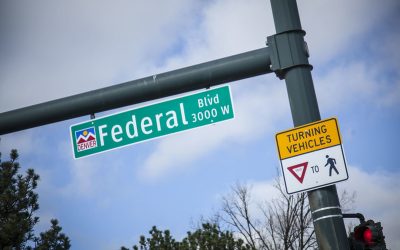
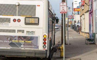
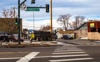
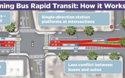
Planning Resources

Westwood Via Verde: Connecting Community Places and Green Spaces

Westwood Via Verde: Connecting Community Places and Green Spaces

The Westwood Via Verde is a three-mile neighborhood greenway project to connect existing and future community amenities and green spaces such as neighborhood bikeways, green streets, parks, and enhanced alleys. Project partners include the City and County of Denver, Westwood Unidos, BuCu West, D3 Arts, Groundwork Denver, Denver Streets Partnership, and many others dedicated to achieving a safer, healthier, and more connected Westwood.

We had every single bus stop on Federal Boulevard assessed – here are the results

Many bus stops in the city lack even the most basic amenities such as seating, protection from the elements, and lighting. We recommend adding these amenities as short-term improvements that would enhance safety, comfort, and convenience for riders along RTD’s second-busiest corridor. On a long-term scale, we recommend much more substantial improvements to Federal’s roadway design and streetscape.

2020 Denver Street Design Summit

2020 Denver Street Design Summit

A summit to explore how Denver can manage competing demands for street space while putting people first. As a leading Vision Zero City, Denver has committed to eliminating traffic fatalities and serious injuries by 2030. Blueprint Denver establishes people walking and...

Federal Boulevard Corridor Study

Federal Boulevard Corridor Study

Federal Blvd is a critical north-south link on Denver’s west side connecting people to local cultural districts and regional destinations. The corridor has the 2nd highest ridership in the RTD bus system, and 26% of Denver residents, more than 16,000 people, live in...

DSP Comments on the East Area Plan

DSP Comments on the East Area Plan

An important step toward realizing the vision and goals embodied in Blueprint Denver is the development of more detailed plans through Denver’s neighborhood planning initiative. Recently the City released the latest draft neighborhood plan for the East Area. We’ve...

Santa Fe Streetscape Study

Santa Fe Streetscape Study

The City and County of Denver Public Works is working to identify, design, and develop pilot streetscape improvements for the Santa Fe Corridor between 8th Avenue and West Colfax Avenue. Santa Fe Drive is an important corridor within the Denver transportation network....

Hampden Corridor Vision Study

Hampden Corridor Vision Study

The Hampden Avenue corridor is a critical east-west arterial near the southern limits of the City and County of Denver serving residents, visitors, shoppers, and employers. The vision for Hampden Avenue is to increase corridor connectivity and provide multimodal...

Go Speer Leetsdale

Go Speer Leetsdale

The City and County of Denver's Speer/Leetsdale Mobility Study examined transportation connectivity and operational needs for travel modes within the Speer/Leetsdale Corridor — a prominent travel route for Denver residents and one piece of the larger travel movement...

Washington Street Study

Washington Street Study

The Washington Street Study Report identifies a vision for Washington Street as a mixed-use riverfront destination area that capitalizes on its adjacency to the South Platte River, a revitalized Washington Street, reinvented greenspace, and direct connections across...

One Federal Boulevard

One Federal Boulevard

In 2017, 11 people died in crashes along Federal, including 7 pedestrians. The rate of fatalities on Federal was 20 times higher than the urban rate on Colorado roadways. To expedite safety improvements, the City and County of Denver is coordinating closely with...

Denver Moves: Enhanced Bikeways

Denver Moves: Enhanced Bikeways

In 2016, Denver Public Works finalized an update to Denver Moves (2011) to plan for enhanced on-street bicycle facilities (e.g., protected bike lanes, neighborhood bikeways) in the downtown area and throughout Denver. This includes: Developing a detailed plan for a...

Denver Moves: Pedestrians & Trails

Denver Moves: Pedestrians & Trails

Denver Moves: Pedestrians and Trails is a citywide plan for completing and improving sidewalks, street crossings and trails – the most essential elements of our transportation network. It also includes recommendations for enhancing our recreational trail network,...

Denver Moves: Transit

Denver Moves: Transit

Denver Moves: Transit is Denver’s first-ever citywide transit plan creating a local transit vision and guiding framework that calls for improving the quality of transit options in our city – making transit more reliable, more frequent, and more convenient for daily...

Blueprint Denver

Blueprint Denver

Blueprint Denver, first adopted in 2002 and updated in 2019, is the City's land use and transportation plan for growing an inclusive and authentic city. The plan is about: Creating complete neighborhoods and complete networks everywhere in our city, to meet the needs...

Denveright

Denveright

Via the city’s three-year Denveright outreach and planning effort, input from thousands of Denverites resulted in plans for a more inclusive, connected and healthy city, for all who live here today, as well as neighbors of tomorrow. The first plan drafts were...

Bus Rapid Transit on Colfax

Bus Rapid Transit on Colfax

The Colfax Corridor Connections project is studying potential long-term mobility improvements for East Colfax Avenue to enhance and revitalize this signature corridor. Through extensive citywide planning efforts and input from the community, the project has identified...

Denver Vision Zero Action Plan

Denver Vision Zero Action Plan

In 2017, the City & County of Denver released the Denver Vision Zero Action Plan, setting the City on a clear path to achieve zero traffic deaths and serious injuries by 2030. To learn more, visit the City's Vision Zero web page. [button...

×
Signup for our Newsletter
Stay up to date on the very latest people-centered transportation design and policy happenings across Denver.