
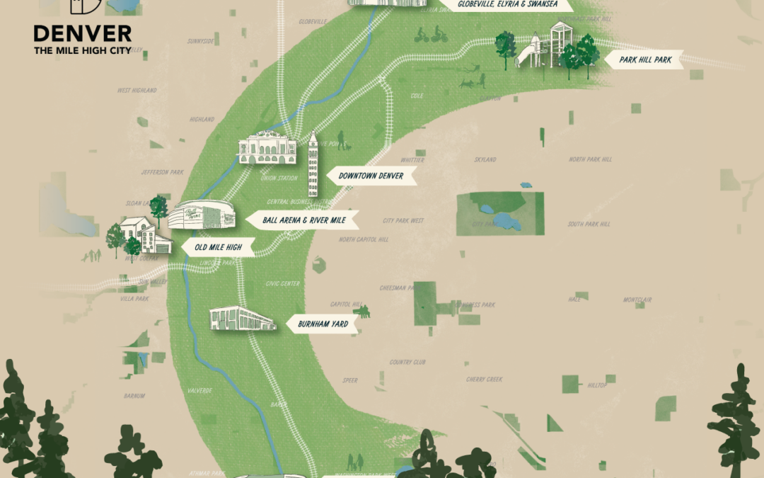
In his 2026 State of the City Address, Mayor Johnston put forward a vision dubbed the Mile High Line, which he describes as “a city that is connected to each other and connected to a shared vision for jobs, housing, transit, climate and equity.”
The Denver Streets Partnership and our coalition partners are here for it, but we want to see real substance behind the fancy name. We sent a letter urging the Johnston administration to pursue the transformative policies and investments in improvements to the multimodal network that we need to fully realize the potential of the Mile High Line. Basically, he needs to put the City’s money (and policies) where his mouth is to make this a real thing.
As shown in the graphic above, the Mile High Line focuses on seven catalytic redevelopment sites all located along rail transit in central Denver: Park Hill Park, the National Western Center, Downtown Denver, Ball Arena & River Mile, Burnham Yard (future Broncos stadium), Old Mile High (current Broncos stadium), and Santa Fe Yards (future Denver Summit stadium). Together these sites provide a once-in-a-generation opportunity to build higher-density, mixed-used development that supports walking, rolling, biking, and transit, while also dramatically improving multimodal connectivity through central Denver.
Conveniently, the City and community-groups around Denver have already done a lot of the hard work to answer the question “How?” We just need Johnston’s administration to prioritize these projects.
Similarly, while the Mile High Line follows the existing Platte River Trail, improvements are needed to further connect many of the catalytic development sites with additional high-quality pedestrian and bicycle routes where they are lacking today.
Major transit routes in Denver that connect to Mile High Line sites and how close they are to meeting Denver Moves Transit service goals
Check out our coalition’s recommendations for the Mile High Line projects
Transit
- Partner with RTD to increase the frequency of transit service, and add transit service where it currently doesn’t exist, to implement the Frequent Transit Network envisioned in Denver Moves Transit.
- Champion the near-term completion of Bus Rapid Transit (BRT), with fully dedicated bus lanes, along the Federal Boulevard, Colorado Boulevard, and Speer/Leetsdale corridors, complementing the Colfax BRT currently under construction to create an actual network of rapid bus routes connecting to the Mile High Line.
- Fully connect transit from downtown along the Welton and Downing corridors to the 38th and Blake A-Line station.
- Work with RTD, DRCOG, and DEN to secure the funding necessary to double-track the A-Line, to accommodate increased demand for travel along this corridor that connects the entire Mile High Line.
Walking & Rolling
- Complete the Broadway bikeway to connect from Speer Boulevard and the Cherry Creek Trail through Downtown to the grade-separated cycle track on Brighton Boulevard.
- Avoid at-grade rail crossings between the La Alma – Lincoln Park neighborhood, Burnham Yard, and other adjacent areas to reduce the risk of collisions with pedestrians, cyclists, and vehicles, reduce noise pollution, and reduce disruptions of rail service.
- Champion and fund the buildout of the 5280 Trail, the 303 ArtWay, and additional planned bicycle facilities from surrounding neighborhoods into the Mile High Line area to create fully-connected, high-quality pedestrian and bicycle routes through central Denver and the Park Hill neighborhood.
Planning & Zoning
- Commit to removing and redesigning the Colfax/Federal cloverleaf interchange to restore the local street grid and prioritize walkable/rollable, connected, transit-oriented development on surrounding parcels.
- Upzone all appropriate areas within the Mile High Line boundaries and along connecting transit routes to encourage transit-supportive densities and mix of uses: at least C-MX-8x within ⅛ mile of a light rail stop; at least G-RX-5x within ¼ mile of light rail and ⅛ mile of BRT centerlines; and at least G-MU-3x within ⅜ mile of light-rail stations, ¼ mile of BRT centerlines, and ⅛ mile of medium-frequency bus stops.
A critical component: Denver Water relocation options
Maybe one of the biggest barriers to prioritizing safe, connected, transit-oriented development along the Mile High Line is the proposed relocation of Denver Water facilities from Burnham Yard to Lot M at Empower Field at Mile High. This move would directly interfere with long-standing plans made collaboratively between the City and the West Colfax community for this area to transform from surface parking and underutilized land into walkable, transit-oriented, mixed-use redevelopment, and for the Colfax & Federal cloverleaf to be redesigned into a safer, more connected urban interchange.
Join us in applauding the Mayor for putting forward this vision, and urge him to take the bold actions necessary to capitalize on this opportunity to create a more connected, affordable, sustainable, and equitable future for all Denverites.