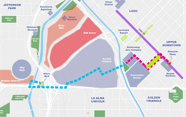
We’re excited to share the efforts of local advocates and community members who want to make Denver’s streets better for people. This is a guest post from Brandon Gilchrist and Jason Schaefer, outlining a new proposal to both pedestrianize two blocks of California Street and connect downtown Denver to Meow Wolf via “the Convergence Trail.”
This proposal comes at the perfect time, as the City is about to update Denver’s Downtown Area Plan (for the first time since 2007)! They’re kicking off the planning process with the first community meeting 5:30–7 p.m., on Wednesday, September 25, 2024. We encourage community members to attend and help shape future downtown developments by expressing support for a pedestrianized California Street and a safer, more accessible downtown area.
By Brandon Gilchrist and Jason Schaefer
There are a number of exciting ideas for making downtown Denver a more pedestrian-friendly, people-focused neighborhood—a great place for residents, workers, and tourists of all ages. We want to offer a vision that will complement other suggestions and help Downtown thrive well into the future.
Introducing Cali Commons
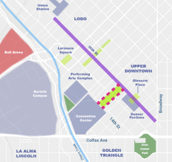
For downtown to thrive in the 21st century, it needs to be more than offices and event spaces. It needs to be a neighborhood, an inviting place for people of all backgrounds to live, work, play, and visit. Pedestrian-focused green corridors are critical to making downtown more livable and California Street, between the Convention Center on 14th Street to the 16th Street Mall, provides an excellent opportunity.
Source: Gilchrist, Schaefer
We envision transforming this section of California Street into a pedestrian-focused area full of shade trees, art, and activity. It would serve as a red carpet from the front door of the Convention Center to 16th Street. Creating an inviting and obvious route from the Convention Center to the 16th Street Mall would increase traffic and visitor spending, helping businesses on 16th Street—particularly the section in the Upper Downtown District, which has suffered the most from the pandemic and the resulting switch to remote work. The Convention Center brings in nearly a million visitors annually who spend $300–$500 million.
Key elements of the design vision
- Existing elements
- Light rail
- Sidewalk
- Trees
- Amenities on the northwest side of California
- Short-term additions
- Flexible components
- Trees and plants
- Shade
- Street paint and public art
- Long-term additions
- Focal point sculpture at 16th and California
- Entry arch near 14th and California to invite Convention Center guests
- Curbless festival street design
Incremental approach
The Cali Commons vision can be implemented in an incremental and cost-efficient manner. It could start with temporary closures on weekends or during big events at the Convention Center. Closing California Street to traffic would create an amazing space for festivals and enhance guest experience while opening up more options for Convention Center event planners.
Initially, low-cost and modular placemaking elements like trees in planters, easy-to-move tables and chairs, and temporary structures could be used. Over time, as the closure becomes more permanent, more enduring features like parklets, painted streets and crosswalks, wayfinding, shade structures, and public art could be added. Ultimately, we envision a curbless festival street with a large focal point sculpture at 16th and California and an archway at 14th and California to entice guests.
One thing we learned during the pandemic is that cities, including Denver, can implement changes quickly and at low cost. Larimer Square and the 2900 block of Larimer in RiNo are good examples of quick and temporary street closures using tactical elements that evolved into more permanent street closures with overwhelming support (86% of businesses and 93% of general survey respondents supported maintaining the closure on the 2900 block of Larimer, for instance).
The case for Cali
Between 14th and 16th Street, California Street already has many of the ingredients to become a prime pedestrianized connection. For starters, it is already designated as a green corridor in both the existing Downtown Area Plan and the Outdoor Downtown master plan. California’s current design only carries traffic in one direction, with two lanes dedicated to vehicle traffic and one lane dedicated to light rail, plus parking on the northwest side of the street. It is not a through street as it terminates at the Convention Center. It does not have any essential driveways or entrances. There are two significant infill development opportunities where existing surface parking lots exist across from the Convention Center and adjacent to the Pavilions. The street has some lovely architecture, particularly the historic Denver Dry Goods building. Recent improvements to the streetscape, including berm trees and planters, complete the charming aesthetic.
The Convergence Trail
Cali Commons is part of our larger vision for a trail connecting Downtown with Meow Wolf.
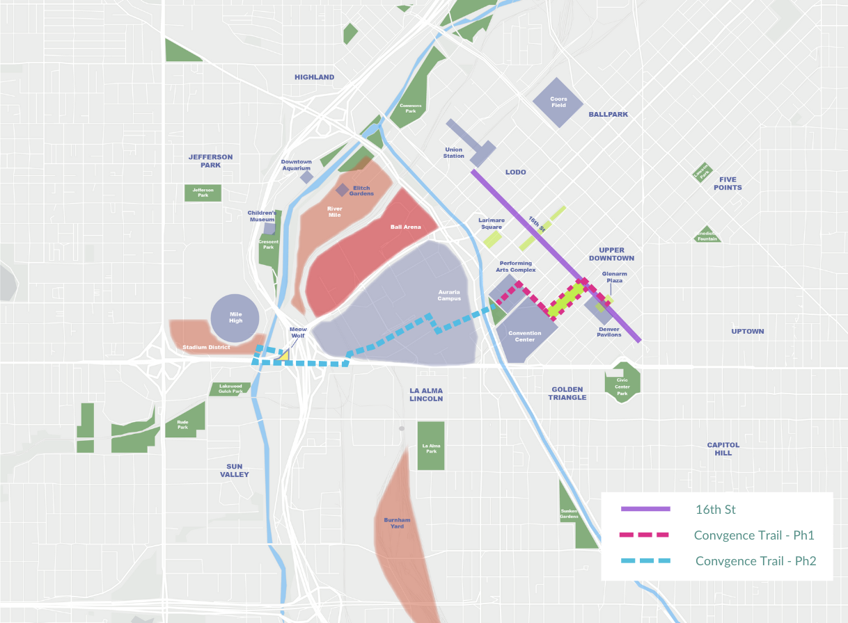
The Convergence Trail, as we’re calling it, is an urban trail connecting downtown Denver to Meow Wolf through a series of green streets and linear parks. The vision is similar to the 5280 Trail and would even overlap with it at one point. The Convergence Trail will feature interactive art and showcase some of Denver’s most unique and iconic amenities and tourist hot spots—becoming an attraction in its own right!
Source: Gilchrist, Schaefer
The trail is split into two broad sections that would be implemented in phases. Phase 1, the downtown section, stretches from Glenarm Plaza to the Denver Performing Arts Complex and Sculpture Park. Phase 2, the western section, continues from Sculpture Park through Auraria Campus, onto the Colfax Viaduct, to Empower Field/Stadium District, and ending at Meow Wolf. The western section is seen as a long term vision since it incorporates future plans to realign Cherry Creek and Speer Boulevard and reimagine the Colfax Viaduct with more space for pedestrians and planned access points near the Auraria West transit station and Empower Field.
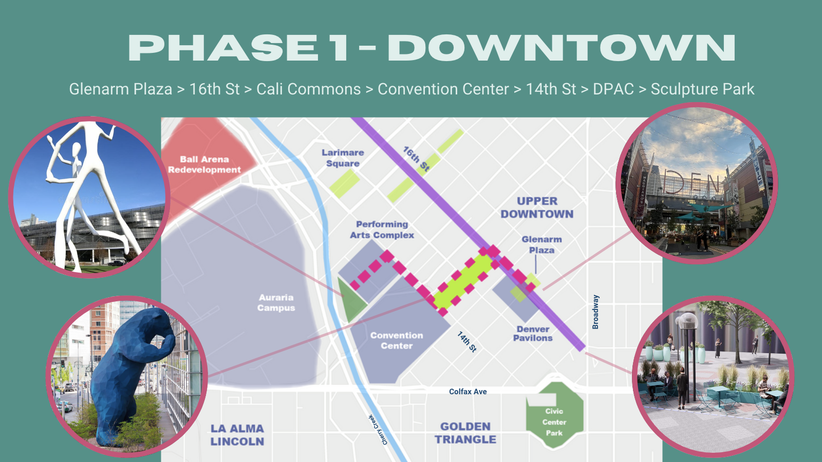
Phase 1 of the Convergence Trail runs from Glenarm Plaza down 16th Street to California Street, where it merges with Cali Commons to the Convention Center, then continues down 14th Street to the Performing Arts Complex, culminating at Sculpture Park.
Source: Gilchrist, Schaefer
Phase 2 of the Convergence Trail incorporates exciting visions for Denver, including a realigned Cherry Creek and Speer Boulevard, plus a reimagined Colfax Viaduct. Those projects allow for a safe and seamless trail that starts at Sculpture Park, crosses Cherry Creek, goes under Speer Boulevard, crosses through Auraria Campus, then takes the Colfax Viaduct to Empower Field and Meow Wolf. It uses previously studied stair/elevator connection points to the Colfax Viaduct near Auraria West Station and Empower Field.
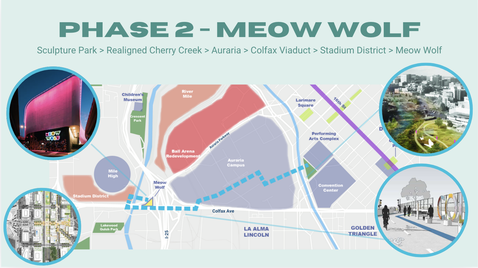
Source: Gilchrist, Schaefer
The Convergence Trail offers an opportunity to connect downtown with Meow Wolf and Empower Field. We envision an interactive art trail through Auraria Campus and along the Colfax Viaduct—think Burning Man-style installations that will bring Meow Wolf’s other-worldliness outside the walls of Convergence Station! We see potential for an exciting public-private partnership with Meow Wolf that could include commissioned public art, such as an iconic sculpture and a satellite storefront near 16th and California Street.
Critical green infrastructure
Green infrastructure, particularly shade trees, becomes increasingly important as the planet gets hotter. Denver is seeing more 100-degree days and record-breaking heat. According to an analysis from Climate Central, downtown experiences a significant heat island effect of around 10 degrees Fahrenheit—more than any other part of the Denver metro.
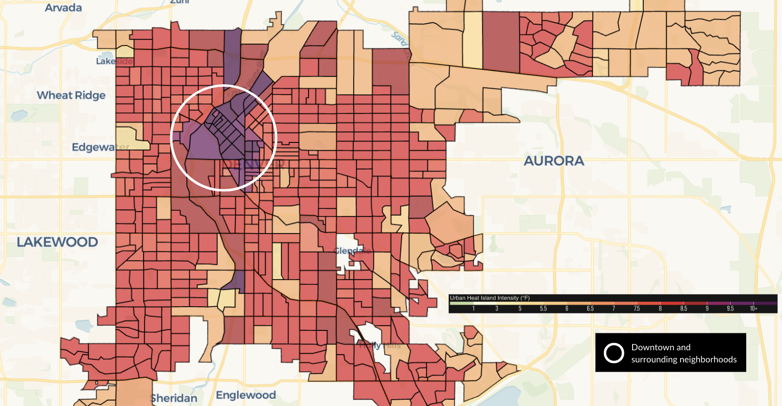
Source: Climate Central analysis of hot spots in 65 cities. The purple color indicates the highest level of heat intensity. The white circle indicates downtown and surrounding neighborhoods.
Medellín, Colombia offers an inspiring example of what is possible. Since 2016, a series of interconnected “Green Corridors” have been developed throughout the city. These corridors expand and link existing green spaces while boosting urban biodiversity.
The $16.3 million initiative has lowered temperatures by 3.6 degrees Fahrenheit and reduced air pollution. Through training provided by Medellín’s Botanical Garden, 75 citizens from disadvantaged backgrounds became city gardeners and helped plant 8,800 trees across the 30 corridors, covering 160 acres.
The Outdoor Downtown master plan included data from a study of 20 cities that found Denver to rank last in urban tree canopy. While the study found the city as a whole to have about 10% canopy coverage, the Office of the City Forester estimated the urban tree canopy in downtown Denver to be a dismal 4%.
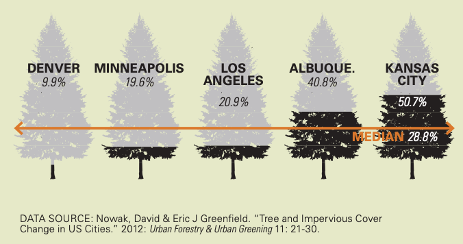
Source: Nowak, David & Eric J Greenfield. “Tree and Impervious Cover Change in US Cities.” 2012: Urban Forestry & Urban Greening 11: 21–30.
Access to parks is another challenge for portions of downtown. Parks not only provide shade and green space but help make downtown more livable. The Outdoor Downtown master plan analyzed which parts of downtown are not within a five-minute walk of a park, as indicated in yellow on the map. The pink dashed line is our proposed route for the downtown section of the Convergence Trail, where it would serve mostly areas that are more than a five-minute walk to a park. The trail would provide a marked route to the existing Sculpture Park, and over time, a path to a new creekside park. The Cali Commons section, combined with the increased tree canopy included in the 16th Street Mall reconstruction, would give this section of downtown some much needed tree canopy and a continuous respite from vehicular traffic.
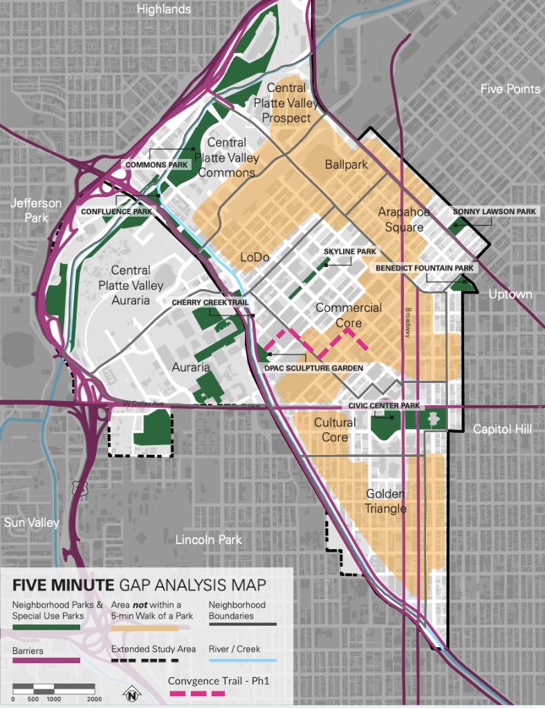
Source: Gilchrist, Schaefer, The Outdoor Downtown master plan (Denver Parks & Recreation, Downtown Denver Partnership)
In Conclusion…
Cali Commons and the Convergence Trail complement other efforts like the 16th Street Mall revitalization, the 5280 Trail, Glenarm Plaza, renovation of Skyline Park, and Larimer Square. This vision ties into Denver’s broader downtown and community goals, including an improved tree canopy, climate resilience, more public space, and a safe, family-friendly downtown with multiple transportation options. It can help attract residents, visitors, companies, and workers—all while helping sustain the critical downtown tax base.
We at the Denver Streets Partnership believe the City needs to prioritize a safer, people-friendly downtown area, if we are to progress towards a truly accessible and equitable Denver. If you do, too, attend the Downtown Area Plan kickoff community meeting on Wednesday, September 25, 2024, to express support for a pedestrianized California Street and a more accessible downtown area.
About the authors
Brandon Gilchrist earned dual masters degrees in Urban Planning and Urban Design from the University of Colorado Denver. He has a deep curiosity for pushing the boundaries of urban living. His specialties in smart city design, public space design, and sustainable planning inform his work; and his previous experience as a corporate event planner give him particular insight and inspiration for the Cali Commons and Convergence Trail concepts.
Jason Schaefer is an urban planner based in Denver. He’s a long-time commuter bicyclist with a career steeped in urbanism including working for Strong Towns, helping to launch a downtown development association in his hometown, and delivering a TEDx talk on Bus Rapid Transit (before BRT was cool!). He has a Master of Urban Planning from the University of Colorado Denver but has also learned a great deal as a tour guide and pedicabber in downtown Denver.

