
A walk along Peoria highlights Montbello’s lack of safe, convenient walking and biking access to the Peoria transit station
Montbello resident Pam Jiner has walked all over northeast Denver. She grew up in Montbello and is now an active leader in the walking communities GirlTrek and Walk2Connect. While there are many streets in the area where sidewalks need to be added, improved, or maintained, Jiner says it’s Peoria Street that needs the most help. “This particular interchange has been quite dangerous for residents for many years – 51 years to be exact – including massive flooding and incomplete and dangerous sidewalks, creating overall unsafe conditions for pedestrians and cyclists.”
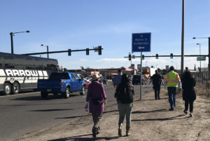
With the Montbello neighborhood bounded by I-70 to the south, the Rocky Mountain Arsenal National Wildlife Refuge to the north, Peña Boulevard to the east, and industrial land uses to the west, it can feel as if residents are trapped in their neighborhood, especially for those who cannot afford a car or sometimes even bus fare. Peoria serves as Montbello’s main street as well as being the main artery connecting the neighborhood across I-70 to the rest of Denver and the new major transit center at Peoria Station.
 Prior to the opening of the Peoria Station south of I-70, the main RTD transit center serving Montbello was located inside the neighborhood at Albrook Drive and Peoria. Now, anyone wanting to walk or bike to the new station must travel down Peoria and traverse both a dangerous highway interchange and the new bridge over the railroad tracks to leave the neighborhood. And with no signage directing people walking and biking toward the station, it’s easy to get lost along the way.
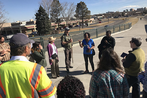
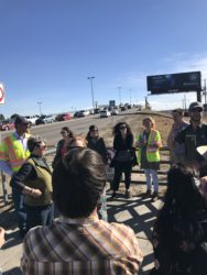
In order to bring attention to the dangers Montbello residents must face on a daily basis to access transit, Jiner teamed up with WalkDenver and Walk2Connect to organize a walk audit of Peoria with a large group of decision makers and local leaders, including representatives from Denver Public Works, Denver Community Planning and Development, CDOT, Councilwoman Stacie Gilmore, Councilman Christopher Herndon, RTD, DPD District 5, Northeast Transportation Connections, and The Foundation for Sustainable Urban Communities. As part of GirlTrek, Jiner also partnered with Stanford University as part of the Our Voice initiative to enable the walk participants to use the Discovery Tool app to record the conditions and their experiences on Peoria while on the walk.
“With the construction getting ready to start on I-70 and with plans currently being drafted and edited, I think it imperative to get everyone out to walk it so it will be fresh in everyone’s minds what the residents of Montbello battle with every single day,” says Jiner. Starting at the Arie P Taylor Municipal Center at 47th & Peoria, where many public services are located, the group walked the mile and a half to the Peoria Station, many navigating the missing sidewalks and crosswalks, fast-moving traffic, steep climbs, and a hidden station entrance for the first time.
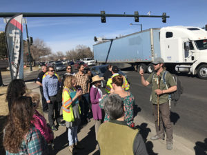

Jonathan Stalls of Walk2Connect gets the discussion started as southbound traffic on Peoria roars by at high speed.

A new detached sidewalk transitions to an informal sidewalk at the property line. Anyone on the sidewalk is forced to travel right next to traffic on Peoria just north of I-70. Sidewalks in Denver are constructed by private property owners when a property is redeveloped. All sidewalks must be maintained by the adjacent property owner, resulting in uneven quality and conditions.
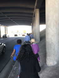

Continuing south on Peoria, anyone walking or biking must use an unpaved strip of curb that is less than three feet wide underneath the I-70 overpass. Residents say this space is covered in slick ice for weeks after it snows.

There are no sidewalks – or even curbs – on either side of Peoria between I-70 and 39th Ave to get to the Peoria Crossing bridge. Footprints and wheelchair and bicycle tracks clearly indicate people travel along Peoria without a vehicle.

The only way to cross the Peoria Street bridge is to use the sidewalk on the east side of Peoria. We were traveling on the west side and reached this dead end without any safe way visible to get to the other side of the street. A road sign just past this point indicates the RTD station is to the west but with no directions for how to get there on foot or bike.
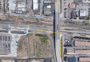

Checking Google Maps for directions proved unhelpful. The app directed us down to 37th Ave (route in blue) but with freight rail tracks located between the street and the station, we stood along 37th looking at the station with no clear or convenient way to get there. After crossing the steep bridge, pedestrians must double-back down a ramp and under the bridge to find the walkway leading to the station (route in yellow) without any signage. Residents have said they continued down Peoria to 33rd Ave, adding an extra half-mile around warehouses and the park-and-ride lot to get to the station before realizing there was a pedestrian shortcut.


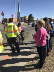
As we made our way back north, the DPD officers who accompanied us often had to stop traffic at ramps that lead on and off the highway. As drivers enter and exit the I-70 ramps at high speeds on wide curves, there are no crosswalks or any indicators that people may be crossing the road.
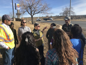
 Councilwoman Stacie Gilmore updates the group on the plans for a multi-use path along the east side of Peoria to connect to 56th from 44th. The area where the group is standing, just north of I-70 on the east side of Peoria, is known as the “Montbello swamp” when it rains or snows.
It was clear to everyone present at the walk that there were several serious issues facing anyone walking or biking between Montbello and the Peoria station. And between the CDOT plans to reconstruct Peoria between 39th Ave and 45th Ave as part of the I-70 reconstruction and the City plans for a multi-use trail along Peoria between 44th Ave and 56th Ave, it is a critical time to ensure that any future infrastructure prioritizes safety for all users. “People of all abilities and ages travel this path multiple times a week,” says Jiner. “The time to fix this historical problem is now!”