
A new network of bikeways will soon link Denver’s central neighborhoods like never before. When bikeways are designed to work together as a network, enhancing the safety of people walking, rolling, biking, and driving alike, people will finally have real choices for how to get around.
")
More Safety. Less Stress.
In order to truly reclaim streets for people, we must reimagine who our streets are for and how we move around our city. The City’s current Community Transportation Networks initiative is designed to provide safer, more connected routes for people walking, biking, and rolling.
What are the Community Networks?
As part of Mayor Hancock’s commitment to a faster buildout of Denver’s bicycle network over the next five years, the City & County of Denver will be working with community members in three areas of the city that will be the first to receive low-stress bike infrastructure and other multimodal improvements. The Community Transportation Networks will be designed to provide safer, more connected routes for people walking, biking, and rolling. Many of the routes have been outlined in the Denver Moves Bicycles Implementation Plan.
More info on Community NetworksWhere are the Community Networks?
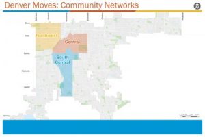
The Community Networks are located in Northwest, Central, and South Central Denver. Check out the map below!
Northwest: Jefferson Park, Sloan’s Lake, Highland, West Highland, Berkeley, Sunnyside, Regis, and Chaffee Park
Central: Auraria, Central Business District, City Park, City Park West, Clayton, Cole, Five Points, Skyland, Union Station, and Whittier
South Central: North Capitol Hill, Capitol Hill, Civic Center, Lincoln Park, Cheeseman Park, Baker, Speer, Washington Park West, Platt Park, Overland, and Rosedale
Important Safety Tips While Walking, Biking, and Rolling

Ways to get involved
Provide feedback to the City as they gather public input
The City wants to hear what it’s like to walk, bike, take transit, and drive in each of the three Community Transportation Networks. They will be hosting virtual public meetings and conducting surveys during the public input process. See below for ways you can share your thoughts.
Online Public Meetings
None scheduled at the moment, stay tuned!
Online Surveys
- S Franklin Street – Buchtel Blvd S to E Dartmouth St
- E Florida Avenue – S Sherman St to S Corona St
- N Pearl St/E 11th Ave/N Emerson St – E 20th Ave to E 3rd Ave
- N Sherman Street – E 20th Ave to E Colfax Ave
- S Sherman Street – E Mississippi Ave to E Harvard Ave
- 2nd Avenue – Galapago St to Pearl St
Walk, roll, or ride along the streets where new projects will go
We’ve created several loops within each Community Network that take you on one or more streets where future projects will be implemented.
Northwest Community Network Loops – View in Google Maps
Meet AJ Rodriguez, Maggierose Martinez, and City Councilman Chris Hinds
They walk, roll, bike, and bus around the Mile High City. They are also the stars of 10 new videos showing some of the ways the Denver Streets Partnership connects decision makers and Denver residents with diverse perspectives, timely information, and practical solutions to prioritize streets for people. Watch and learn why Community Transportation Networks are important for these three Denverites.